
Tunceli merkez topographic map
Interactive map
Click on the map to display elevation.
About this map
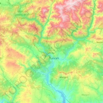
Name: Tunceli merkez topographic map, elevation, terrain.
Location: Tunceli merkez, Tunceli, Doğu Anadolu Bölgesi, 62000, Turquía (38.90030 39.29733 39.37169 39.78706)
Average elevation: 1,536 m
Minimum elevation: 824 m
Maximum elevation: 3,112 m
Other topographic maps
Click on a map to view its topography, its elevation and its terrain.
Kongur
Turquía > Doğu Anadolu Bölgesi > Kongur
Kongur, Hınıs, Erzurum, Doğu Anadolu Bölgesi, Turquía
Average elevation: 1,898 m