
Make a donation
Gear up for your next adventure:
As an Amazon Associate, this site earns from qualifying purchases at no extra cost to you.
Wagrain topographic map
Click on the map to display elevation.
Make a donation
Gear up for your next adventure:
As an Amazon Associate, this site earns from qualifying purchases at no extra cost to you.
About this map
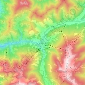
Name: Wagrain topographic map, elevation, terrain.
Location: Wagrain, Bezirk St. Johann im Pongau, Salzburg, 5602, Austria (47.28430 13.25732 47.38489 13.36522)
Average elevation: 1,300 m
Minimum elevation: 704 m
Maximum elevation: 2,002 m
Make a donation
Gear up for your next adventure:
As an Amazon Associate, this site earns from qualifying purchases at no extra cost to you.
Other topographic maps
Click on a map to view its topography, its elevation and its terrain.
Alpendorf
Austria > Salzburg > Bezirk St. Johann im Pongau > Sankt Johann im Pongau
Alpendorf (German for alpine village) is a village and a part of the town St. Johann im Pongau. It is 55 km (34 mi) south of the Austrian city of Salzburg. It is at an altitude of 850 m (2,790 ft) above sea level.
Average elevation: 880 m
Zauchensee
Austria > Salzburg > Bezirk St. Johann im Pongau > Altenmarkt im Pongau
Average elevation: 1,696 m
Rohrmoos
Austria > Salzburg > Bezirk St. Johann im Pongau > Mühlbach am Hochkönig
Average elevation: 1,103 m