
Rhosbodrual topographic map
Interactive map
Click on the map to display elevation.
About this map
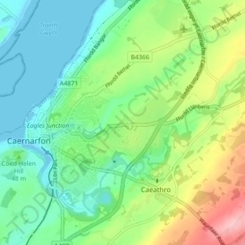
Name: Rhosbodrual topographic map, elevation, terrain.
Average elevation: 46 m
Minimum elevation: 0 m
Maximum elevation: 143 m
Other topographic maps
Click on a map to view its topography, its elevation and its terrain.
Castell Caernarfon
United Kingdom > Wales > Gwynedd > Caernarfon
Castell Caernarfon, Castle Ditch, Caernarfon, Gwynedd, Wales, LL55 2AY, United Kingdom
Average elevation: 18 m