
Sabah District topographic map
Interactive map
Click on the map to display elevation.
About this map
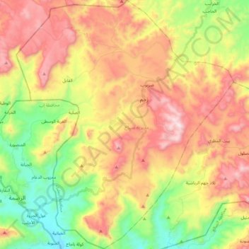
Name: Sabah District topographic map, elevation, terrain.
Location: Sabah District, Al Bayda' Governorate, Yemen (14.18310 44.58628 14.36878 44.75396)
Average elevation: 2,477 m
Minimum elevation: 1,996 m
Maximum elevation: 3,001 m
Other topographic maps
Click on a map to view its topography, its elevation and its terrain.
Al Malagim District
Al Malagim District, Al Bayda' Governorate, Yemen
Average elevation: 1,962 m
Nawbah
Yemen > Al Bayda' Governorate > Nawbah
Nawbah, Al Bayda District, Al Bayda' Governorate, Yemen
Average elevation: 1,990 m
Al Hazm
Yemen > Al Bayda' Governorate > Al Hazm
Al Hazm, Na'man District, Al Bayda' Governorate, Yemen
Average elevation: 1,495 m
Al Beidha
Yemen > Al Bayda' Governorate > Al Beidha
Al Beidha, Al Bayda City District, Al Bayda' Governorate, Yemen
Average elevation: 2,039 m
Ar Raqqah
Yemen > Al Bayda' Governorate > Ar Raqqah
Ar Raqqah, Radman District, Al Bayda' Governorate, Yemen
Average elevation: 2,008 m
Laqah
Yemen > Al Bayda' Governorate > Laqah
Laqah, Al Bayda' Governorate, Yemen
Average elevation: 2,125 m