Geolocate

Hatta topographic map

Click on the map to display elevation.

About this map

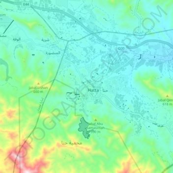
Name: Hatta topographic map, elevation, terrain.

Location: Hatta, Dubai, United Arab Emirates (24.75910 56.07494 24.83910 56.15494)

Average elevation: 434 m

Minimum elevation: 272 m

Maximum elevation: 1,044 m

Other topographic maps

Click on a map to view its topography, its elevation and its terrain.

Hatta Hill Park

United Arab Emirates > Dubai > Hatta

Average elevation: 334 m

Hatta

United Arab Emirates > Dubai > Hatta

Average elevation: 422 m

Gear up for your next adventure:

🎒Hiking Daypacks (20L) - Compact backpacks for day trips and technical mountain ascents
🚲Cycling GPS Computers - Track elevation and topographic routes on two wheels
👕Merino Base Layers - Natural temperature regulation for cold weather hiking and camping
👖Convertible Hiking Trousers - Versatile zip-off pants for changing mountain weather conditions
🦶Anti-Blister Balms - Protect your feet before long topographic expeditions

As an Amazon Associate, this site earns from qualifying purchases at no extra cost to you.