Geolocate

North Georgetown topographic map

Click on the map to display elevation.

About this map

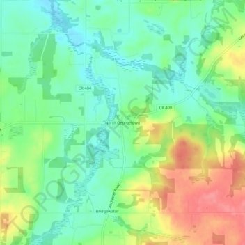
Name: North Georgetown topographic map, elevation, terrain.

Location: North Georgetown, Columbiana County, Ohio, 44665, United States (40.82311 -81.00592 40.86311 -80.96592)

Average elevation: 357 m

Minimum elevation: 327 m

Maximum elevation: 405 m

Other topographic maps

Click on a map to view its topography, its elevation and its terrain.

Wellsville

United States > Ohio > Columbiana County

The elevation is 682 feet above sea level.

Average elevation: 269 m

Salem

United States > Ohio > Columbiana County

Average elevation: 375 m

Columbiana

United States > Ohio > Columbiana County

Average elevation: 346 m

Lisbon

United States > Ohio > Columbiana County

Average elevation: 334 m

East Liverpool

United States > Ohio > Columbiana County

Average elevation: 304 m

East Palestine

United States > Ohio > Columbiana County

Average elevation: 341 m

Salem

United States > Ohio > Columbiana County

Average elevation: 375 m

Gear up for your next adventure:

🚶Walking Pedometers - Simple distance tracking for casual trail walkers
🥾Hiking Boots - Waterproof and durable boots for long-distance hiking in the UK
🧥Softshell Jackets - Breathable jackets for active outdoor use
🧥Packable Down Jackets - Lightweight warmth that compresses small in your bag
🐕Hiking Dog Harnesses - Rugged harnesses for taking your companion on mountain trails

As an Amazon Associate, this site earns from qualifying purchases at no extra cost to you.