
Sériès topographic map
Interactive map
Click on the map to display elevation.
About this map
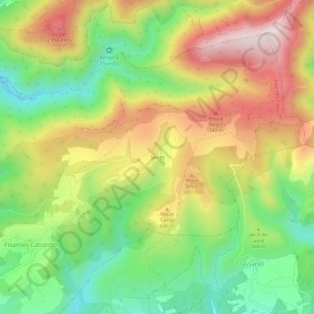
Name: Sériès topographic map, elevation, terrain.
Average elevation: 564 m
Minimum elevation: 321 m
Maximum elevation: 849 m
Other topographic maps
Click on a map to view its topography, its elevation and its terrain.
La Pierre Plantée
France > Occitanie > Aude > Fournes-Cabardès > Sériès
La Pierre Plantée, D 401, Sériès, Fournes-Cabardès, Carcassonne, Aude, Occitanie, France métropolitaine, 11600, France
Average elevation: 525 m