
Candanchú topographic map
Interactive map
Click on the map to display elevation.
About this map
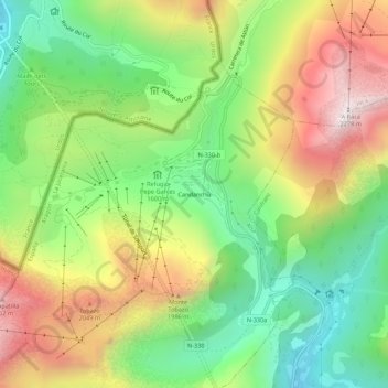
Name: Candanchú topographic map, elevation, terrain.
Location: Candanchú, Aísa, La Jacetania, Aragón, 22889, España (42.76536 -0.54665 42.80536 -0.50665)
Average elevation: 1,686 m
Minimum elevation: 1,243 m
Maximum elevation: 2,278 m
Other topographic maps
Click on a map to view its topography, its elevation and its terrain.
Pico de Aspe
España > Aragón > La Jacetania > Aísa
Pico de Aspe, Aísa, La Jacetania, Huesca, Aragón, 22889, España
Average elevation: 2,181 m