
Greifenberg topographic map
Interactive map
Click on the map to display elevation.
About this map
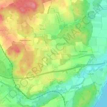
Name: Greifenberg topographic map, elevation, terrain.
Average elevation: 575 m
Minimum elevation: 533 m
Maximum elevation: 625 m
Other topographic maps
Click on a map to view its topography, its elevation and its terrain.
Untermühlhausen
Germany > Bavaria > Landkreis Landsberg am Lech
Untermühlhausen, Penzing, Landkreis Landsberg am Lech, Bavaria, 86929, Germany
Average elevation: 601 m
Thaining
Germany > Bavaria > Landkreis Landsberg am Lech
Thaining, Reichling, Landkreis Landsberg am Lech, Bavaria, 86943, Germany
Average elevation: 682 m