Geolocate

Visby topographic map

Click on the map to display elevation.

About this map
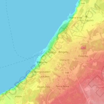
Name: Visby topographic map, elevation, terrain.

Location: Visby, Gotland Municipality, Gotland County, 621 45, Sweden (57.47794 18.13798 57.79794 18.45798)

Average elevation: 23 m

Minimum elevation: 0 m

Maximum elevation: 83 m

Other topographic maps

Click on a map to view its topography, its elevation and its terrain.
Gotland Municipality

Sweden > Gotland County

Average elevation: 2 m

Fårö

Sweden > Gotland County

Average elevation: 5 m

Gotland Municipality

Sweden > Gotland County

Average elevation: 2 m

Gear up for your next adventure:

🥤Hydration Bladders - Hands-free hydration systems for backpacks
🎒Replacement Sternum Straps - Repair parts for hiking rucksacks
🎒Backpack Rain Covers - Universal waterproof covers to protect your gear from downpours
🥾Walking Shoes - Lightweight walking shoes for countryside and coastal paths
🥾Hiking Boot Waterproofing Wax - Maintain the lifespan of your leather trekking boots

As an Amazon Associate, this site earns from qualifying purchases at no extra cost to you.