
Make a donation
Gear up for your next adventure:
As an Amazon Associate, this site earns from qualifying purchases at no extra cost to you.
Invermere topographic map
Click on the map to display elevation.
Make a donation
Gear up for your next adventure:
As an Amazon Associate, this site earns from qualifying purchases at no extra cost to you.
About this map
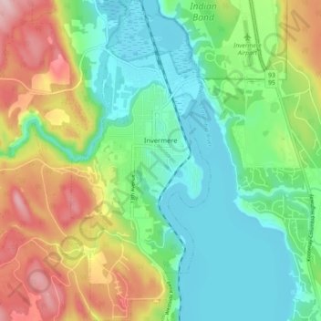
Name: Invermere topographic map, elevation, terrain.
Average elevation: 876 m
Minimum elevation: 795 m
Maximum elevation: 1,027 m
Make a donation
Gear up for your next adventure:
As an Amazon Associate, this site earns from qualifying purchases at no extra cost to you.
Other topographic maps
Click on a map to view its topography, its elevation and its terrain.
Rocky Mountains
Canada > British Columbia > Regional District of East Kootenay > Area A (Upper Flathead/Elk Valley)
Average elevation: 2,159 m
Spillimacheen
Canada > British Columbia > Regional District of East Kootenay > Area G (Forster Creek/Mount Assiniboine)
Average elevation: 971 m
Fort Steele
Canada > British Columbia > Regional District of East Kootenay > Area C (Moyie/Bull River)
Average elevation: 797 m
Whiteswan Lake
Canada > British Columbia > Regional District of East Kootenay > Area F (Columbia Lake/Windermere Lake)
Average elevation: 1,392 m
Make a donation
Gear up for your next adventure:
As an Amazon Associate, this site earns from qualifying purchases at no extra cost to you.
Mount Strachan
Canada > British Columbia > Regional District of East Kootenay > Area A (Upper Flathead/Elk Valley)
Average elevation: 2,198 m
Shuswap
Canada > British Columbia > Regional District of East Kootenay > Area F (Columbia Lake/Windermere Lake)
Average elevation: 926 m
Wardner
Canada > British Columbia > Regional District of East Kootenay > Area C (Moyie/Bull River)
Average elevation: 815 m
Bull Mountain
Canada > British Columbia > Regional District of East Kootenay > Area C (Moyie/Bull River)
Average elevation: 2,068 m
Make a donation
Gear up for your next adventure:
As an Amazon Associate, this site earns from qualifying purchases at no extra cost to you.
The Nublet
Canada > British Columbia > Regional District of East Kootenay > Area G (Forster Creek/Mount Assiniboine)
Average elevation: 2,301 m
Fording River
Canada > British Columbia > Regional District of East Kootenay > Elkford
Average elevation: 1,787 m
Fairmont Hot Springs
Canada > British Columbia > Regional District of East Kootenay > Area F (Columbia Lake/Windermere Lake)
Average elevation: 920 m
Upper Elk Lake
Canada > British Columbia > Regional District of East Kootenay > Area A (Upper Flathead/Elk Valley)
Average elevation: 1,982 m
Make a donation
Gear up for your next adventure:
As an Amazon Associate, this site earns from qualifying purchases at no extra cost to you.
Wasa Lake
Canada > British Columbia > Regional District of East Kootenay > Area E (Saint Mary/Skookumchuck) > Wasa
Average elevation: 793 m
Kootenay National Park
Canada > British Columbia > Regional District of East Kootenay
Kootenay National Park is a national park located in southeastern British Columbia, Canada, and is one component of the Canadian Rocky Mountain Parks World Heritage Site. The park consists of 1,406 km2 (543 sq mi) of the Canadian Rockies, including parts of the Kootenay and Park mountain ranges, the Kootenay…
Average elevation: 1,832 m
Lazy Lake
Canada > British Columbia > Regional District of East Kootenay > Area E (Saint Mary/Skookumchuck)
Average elevation: 1,080 m
Kragmont
Canada > British Columbia > Regional District of East Kootenay > Area B (Lake Koocanusa)
Average elevation: 788 m
Make a donation
Gear up for your next adventure:
As an Amazon Associate, this site earns from qualifying purchases at no extra cost to you.
Tumbling NE5
Canada > British Columbia > Regional District of East Kootenay > Area G (Forster Creek/Mount Assiniboine)
Average elevation: 2,146 m
Monroe Lake
Canada > British Columbia > Regional District of East Kootenay > Area C (Moyie/Bull River)
Average elevation: 1,105 m
The Bugaboos
Canada > British Columbia > Regional District of East Kootenay > Area G (Forster Creek/Mount Assiniboine)
Average elevation: 2,412 m
Purcell Mountains
Canada > British Columbia > Regional District of East Kootenay > Area G (Forster Creek/Mount Assiniboine)
Average elevation: 2,710 m
Make a donation
Gear up for your next adventure:
As an Amazon Associate, this site earns from qualifying purchases at no extra cost to you.
Fernie
Canada > British Columbia > Regional District of East Kootenay > Fernie
Average elevation: 1,551 m
Grizzly Peak
Canada > British Columbia > Regional District of East Kootenay > Area A (Upper Flathead/Elk Valley)
Average elevation: 1,962 m
Morrissey Provincial Park
Canada > British Columbia > Regional District of East Kootenay > Area A (Upper Flathead/Elk Valley)
Average elevation: 1,040 m
Findlay Creek
Canada > British Columbia > Regional District of East Kootenay > Area F (Columbia Lake/Windermere Lake)
Average elevation: 1,270 m
Make a donation
Gear up for your next adventure:
As an Amazon Associate, this site earns from qualifying purchases at no extra cost to you.
Ta Ta Creek
Canada > British Columbia > Regional District of East Kootenay > Area E (Saint Mary/Skookumchuck)
Average elevation: 854 m
Maiden Lake
Canada > British Columbia > Regional District of East Kootenay > Fernie
Average elevation: 1,045 m
Big White Peak
Canada > British Columbia > Regional District of East Kootenay > Area B (Lake Koocanusa)
Average elevation: 1,860 m
Jim Smith Lake
Canada > British Columbia > Regional District of East Kootenay > Area C (Moyie/Bull River)
Average elevation: 1,091 m
Make a donation
Gear up for your next adventure:
As an Amazon Associate, this site earns from qualifying purchases at no extra cost to you.
Baynes Lake
Canada > British Columbia > Regional District of East Kootenay > Area B (Lake Koocanusa)
Average elevation: 796 m
Gold Creek
Canada > British Columbia > Regional District of East Kootenay > Area B (Lake Koocanusa)
Average elevation: 823 m
Barnes Lake
Canada > British Columbia > Regional District of East Kootenay > Area A (Upper Flathead/Elk Valley)
Average elevation: 2,073 m
Elk River
Canada > British Columbia > Regional District of East Kootenay > Fernie
Average elevation: 1,134 m
Make a donation
Gear up for your next adventure:
As an Amazon Associate, this site earns from qualifying purchases at no extra cost to you.
Moyie
Canada > British Columbia > Regional District of East Kootenay > Area C (Moyie/Bull River)
Average elevation: 1,164 m
Tent Mountain
Canada > British Columbia > Regional District of East Kootenay > Area A (Upper Flathead/Elk Valley)
Average elevation: 1,873 m
Mount Fernie
Canada > British Columbia > Regional District of East Kootenay > Area A (Upper Flathead/Elk Valley)
Average elevation: 1,804 m
Grave Lake
Canada > British Columbia > Regional District of East Kootenay > Area A (Upper Flathead/Elk Valley)
Average elevation: 1,426 m
Make a donation
Gear up for your next adventure:
As an Amazon Associate, this site earns from qualifying purchases at no extra cost to you.
Mount Farnham
Canada > British Columbia > Regional District of East Kootenay > Area G (Forster Creek/Mount Assiniboine)
Average elevation: 2,791 m
Mount Worthington
Canada > British Columbia > Regional District of East Kootenay > Area F (Columbia Lake/Windermere Lake)
Average elevation: 2,421 m
Steeples
Canada > British Columbia > Regional District of East Kootenay > Cranbrook
Average elevation: 940 m
Mount Bisaro
Canada > British Columbia > Regional District of East Kootenay > Area C (Moyie/Bull River)
Average elevation: 2,115 m
Make a donation
Gear up for your next adventure:
As an Amazon Associate, this site earns from qualifying purchases at no extra cost to you.
Baptiste Lake
Canada > British Columbia > Regional District of East Kootenay > Area G (Forster Creek/Mount Assiniboine)
Average elevation: 1,067 m
Elko
Canada > British Columbia > Regional District of East Kootenay > Area B (Lake Koocanusa)
Average elevation: 1,016 m
Elkford
Canada > British Columbia > Regional District of East Kootenay > Elkford > Elkford
Average elevation: 1,544 m
Mount Erickson
Canada > British Columbia > Regional District of East Kootenay > Area A (Upper Flathead/Elk Valley)
Average elevation: 1,938 m
Make a donation
Gear up for your next adventure:
As an Amazon Associate, this site earns from qualifying purchases at no extra cost to you.
Caribou Park
Canada > British Columbia > Regional District of East Kootenay > Elkford
Average elevation: 1,323 m
Cobb Lake
Canada > British Columbia > Regional District of East Kootenay > Area G (Forster Creek/Mount Assiniboine)
Average elevation: 1,366 m
Redding Creek
Canada > British Columbia > Regional District of East Kootenay > Area E (Saint Mary/Skookumchuck)
Average elevation: 1,762 m
Purcell Mountains
Canada > British Columbia > Regional District of East Kootenay > Area G (Forster Creek/Mount Assiniboine)
Average elevation: 2,710 m
Make a donation
Gear up for your next adventure:
As an Amazon Associate, this site earns from qualifying purchases at no extra cost to you.
Lockwood Peak
Canada > British Columbia > Regional District of East Kootenay > Area F (Columbia Lake/Windermere Lake)
Average elevation: 2,225 m
Panorama Mountain Village
Canada > British Columbia > Regional District of East Kootenay > Area F (Columbia Lake/Windermere Lake)
Average elevation: 1,412 m
Grasmere
Canada > British Columbia > Regional District of East Kootenay > Area B (Lake Koocanusa)
Average elevation: 1,067 m
Rocky Mountains
Canada > British Columbia > Regional District of East Kootenay > Area A (Upper Flathead/Elk Valley)
Average elevation: 2,159 m
Make a donation
Gear up for your next adventure:
As an Amazon Associate, this site earns from qualifying purchases at no extra cost to you.
Valley of the Rocks
Canada > British Columbia > Regional District of East Kootenay > Area G (Forster Creek/Mount Assiniboine)
Average elevation: 2,198 m
Mount Allen
Canada > British Columbia > Regional District of East Kootenay > Area G (Forster Creek/Mount Assiniboine)
Average elevation: 2,674 m
Mount Strachan
Canada > British Columbia > Regional District of East Kootenay > Area A (Upper Flathead/Elk Valley)
Average elevation: 2,198 m
Wilmer
Canada > British Columbia > Regional District of East Kootenay > Area G (Forster Creek/Mount Assiniboine)
Average elevation: 881 m
Make a donation
Gear up for your next adventure:
As an Amazon Associate, this site earns from qualifying purchases at no extra cost to you.
Windermere
Canada > British Columbia > Regional District of East Kootenay > Area F (Columbia Lake/Windermere Lake)
Average elevation: 842 m