
Make a donation
Gear up for your next adventure:
As an Amazon Associate, this site earns from qualifying purchases at no extra cost to you.
Mount Bisaro topographic map
Click on the map to display elevation.
Make a donation
Gear up for your next adventure:
As an Amazon Associate, this site earns from qualifying purchases at no extra cost to you.
About this map
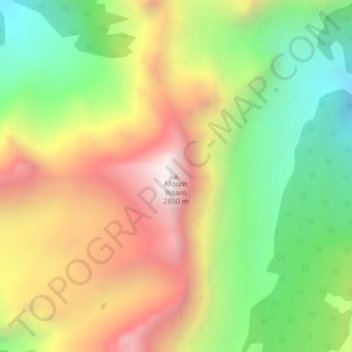
Name: Mount Bisaro topographic map, elevation, terrain.
Average elevation: 2,115 m
Minimum elevation: 1,481 m
Maximum elevation: 2,842 m
Make a donation
Gear up for your next adventure:
As an Amazon Associate, this site earns from qualifying purchases at no extra cost to you.
Other topographic maps
Click on a map to view its topography, its elevation and its terrain.
Monroe Lake
Canada > British Columbia > Regional District of East Kootenay > Area C (Moyie/Bull River)
Average elevation: 1,105 m
Moyie Lake
Canada > British Columbia > Regional District of East Kootenay > Area C (Moyie/Bull River) > Moyie
Average elevation: 1,185 m
Jim Smith Lake
Canada > British Columbia > Regional District of East Kootenay > Area C (Moyie/Bull River)
Average elevation: 1,091 m