
Thank you for supporting this site ❤️
Make a donation
Make a donation
Gear up for your next adventure:
As an Amazon Associate, this site earns from qualifying purchases at no extra cost to you.
Avarua topographic map
Click on the map to display elevation.
Thank you for supporting this site ❤️
Make a donation
Make a donation
Gear up for your next adventure:
As an Amazon Associate, this site earns from qualifying purchases at no extra cost to you.
About this map
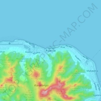
Name: Avarua topographic map, elevation, terrain.
Location: Avarua, Te-Au-O-Tonga, Rarotonga, Cook Islands (-21.24747 -159.81081 -21.16747 -159.73081)
Average elevation: 79 m
Minimum elevation: 0 m
Maximum elevation: 537 m
Thank you for supporting this site ❤️
Make a donation
Make a donation
Gear up for your next adventure:
As an Amazon Associate, this site earns from qualifying purchases at no extra cost to you.