
Regione di Los Ríos topographic map
Interactive map
Click on the map to display elevation.
About this map
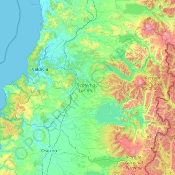
Name: Regione di Los Ríos topographic map, elevation, terrain.
Location: Regione di Los Ríos, Cile (-40.68097 -73.72509 -39.28735 -71.59266)
Average elevation: 431 m
Minimum elevation: -2 m
Maximum elevation: 2,781 m
Other topographic maps
Click on a map to view its topography, its elevation and its terrain.
Valdivia
Cile > Regione di Los Ríos > Valdivia
Valdivia, Provincia de Valdivia, Regione di Los Ríos, Cile
Average elevation: 143 m