
Sultanbeyli topographic map
Interactive map
Click on the map to display elevation.
About this map
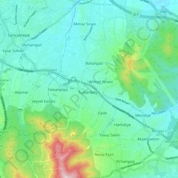
Name: Sultanbeyli topographic map, elevation, terrain.
Location: Sultanbeyli, İstanbul, Marmararegion, Türkei (40.93129 29.24472 41.00488 29.31194)
Average elevation: 172 m
Minimum elevation: 73 m
Maximum elevation: 534 m
Other topographic maps
Click on a map to view its topography, its elevation and its terrain.
Aydos (Aetos) Kalesi
Aydos (Aetos) Kalesi, Şalgamlı Devlet Ormanı Mah., Şalgamlı Devlet Ormanı, Sultanbeyli, İstanbul, Marmararegion, 34925, Türkei
Average elevation: 259 m