Geolocate

Bangar topographic map

Click on the map to display elevation.

About this map

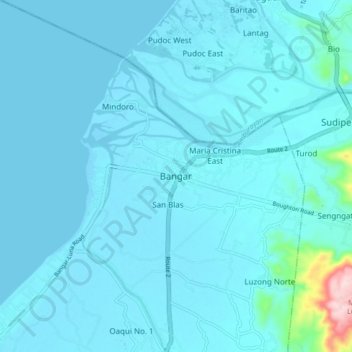
Name: Bangar topographic map, elevation, terrain.

Location: Bangar, La Union, Ilocos Region, 2519, Philippines (16.85378 120.38296 16.93378 120.46296)

Average elevation: 18 m

Minimum elevation: -2 m

Maximum elevation: 273 m

Gear up for your next adventure:

🐕Dog Hiking Gear - Equipment for hiking safely with dogs
🧵Survival Paracord - Multi-purpose cordage for emergency repairs and shelters
🪢Paracord - Multi-purpose cord for camping and survival
🚲Cycling GPS Computers - Track elevation and topographic routes on two wheels
🧣Neck Gaiters - Protects against wind and sun on exposed ridges and peaks

As an Amazon Associate, this site earns from qualifying purchases at no extra cost to you.