Geolocate

Bithlo topographic map

Click on the map to display elevation.

About this map

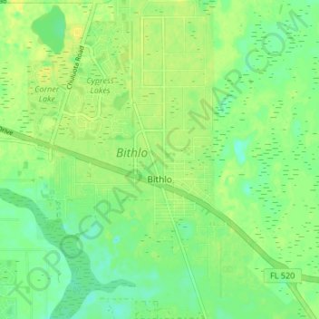
Name: Bithlo topographic map, elevation, terrain.

Location: Bithlo, Orange County, Florida, United States (28.52889 -81.13659 28.58767 -81.08151)

Average elevation: 21 m

Minimum elevation: 10 m

Maximum elevation: 30 m

Gear up for your next adventure:

🥾Walking Shoes - Lightweight walking shoes for countryside and coastal paths
🌦️Portable Weather Meters - Handheld tools for monitoring weather conditions
Insulated Travel Mugs - Keep drinks hot while surveying the landscape from a summit
🔦LED Camping Lanterns - Illumination for reading maps inside your tent at night
🗺️Topographic Maps - Detailed maps showing elevation and terrain features

As an Amazon Associate, this site earns from qualifying purchases at no extra cost to you.