Geolocate

Baglan topographic map

Click on the map to display elevation.

About this map

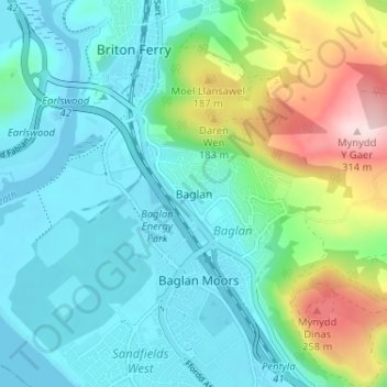
Name: Baglan topographic map, elevation, terrain.

Location: Baglan, Neath Port Talbot, Wales, SA12 8TY, United Kingdom (51.60107 -3.83164 51.64107 -3.79164)

Average elevation: 75 m

Minimum elevation: -4 m

Maximum elevation: 312 m

Neath Port Talbot trails, hiking, mountain biking, running and outdoor activities

Other topographic maps

Click on a map to view its topography, its elevation and its terrain.

River Neath

United Kingdom > Wales > Neath Port Talbot > Resolven

Average elevation: 272 m

Glynneath

United Kingdom > Wales > Neath Port Talbot

Average elevation: 246 m

Cilybebyll

United Kingdom > Wales > Neath Port Talbot > Gellinudd

Average elevation: 179 m

Pelenna

United Kingdom > Wales > Neath Port Talbot

Average elevation: 217 m

Crynant

United Kingdom > Wales > Neath Port Talbot

Average elevation: 232 m

Neath

United Kingdom > Wales > Neath Port Talbot

Average elevation: 71 m

Pontardawe

United Kingdom > Wales > Neath Port Talbot

Average elevation: 180 m

Gear up for your next adventure:

GPS Outdoor Watches - Watches with GPS tracking for hiking and exploration
🔋Power Banks - Portable chargers for long outdoor trips
👟Waterproof Leg Gaiters - Keep mud and water out of your boots in boggy terrain
📢Survival Whistles - Essential safety gear for signaling for help in mountain fog
🦯Walking Poles - Supportive poles for long-distance walking

As an Amazon Associate, this site earns from qualifying purchases at no extra cost to you.