
Malvern topographic map
Interactive map
Click on the map to display elevation.
About this map
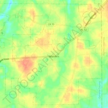
Name: Malvern topographic map, elevation, terrain.
Location: Malvern, Geneva County, Alabama, United States (31.10996 -85.56179 31.17154 -85.48529)
Average elevation: 86 m
Minimum elevation: 64 m
Maximum elevation: 107 m
Other topographic maps
Click on a map to view its topography, its elevation and its terrain.
Somerset
United States > Alabama > Geneva County > Geneva
Somerset, Geneva, Geneva County, Alabama, 36340, United States
Average elevation: 42 m
Lowery
United States > Alabama > Geneva County > Lowery
Lowery, Geneva County, Alabama, United States
Average elevation: 62 m