
Make a donation
Gear up for your next adventure:
As an Amazon Associate, this site earns from qualifying purchases at no extra cost to you.
Paulin topographic map
Click on the map to display elevation.
Make a donation
Gear up for your next adventure:
As an Amazon Associate, this site earns from qualifying purchases at no extra cost to you.
Paulin
Le département de la Dordogne se présente comme un vaste plateau incliné du nord-est (491 m, à la forêt de Vieillecour dans le Nontronnais, à Saint-Pierre-de-Frugie) au sud-ouest (2 m à Lamothe-Montravel). L'altitude du territoire communal varie quant à elle entre 191 mètres et 329 mètres.
Make a donation
Gear up for your next adventure:
As an Amazon Associate, this site earns from qualifying purchases at no extra cost to you.
About this map
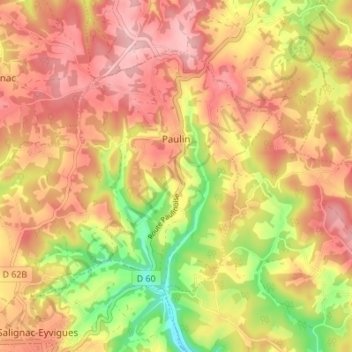
Name: Paulin topographic map, elevation, terrain.
Average elevation: 274 m
Minimum elevation: 180 m
Maximum elevation: 335 m
Make a donation
Gear up for your next adventure:
As an Amazon Associate, this site earns from qualifying purchases at no extra cost to you.
Other topographic maps
Click on a map to view its topography, its elevation and its terrain.
Les Illarets
France > Nouvelle-Aquitaine > Dordogne > Saint-Michel-de-Montaigne
Average elevation: 43 m
Make a donation
Gear up for your next adventure:
As an Amazon Associate, this site earns from qualifying purchases at no extra cost to you.
Le Bost
France > Nouvelle-Aquitaine > Dordogne > Eyraud-Crempse-Maurens > Le Bost
Average elevation: 118 m
Make a donation
Gear up for your next adventure:
As an Amazon Associate, this site earns from qualifying purchases at no extra cost to you.