
Rayaa Masaida topographic map
Interactive map
Click on the map to display elevation.
About this map
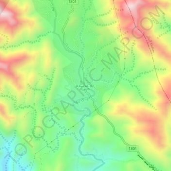
Name: Rayaa Masaida topographic map, elevation, terrain.
Location: Rayaa Masaida, Al Aydabi, Jazan Province, Saudi Arabia (17.35666 43.05354 17.39666 43.09354)
Average elevation: 1,015 m
Minimum elevation: 719 m
Maximum elevation: 1,423 m
Other topographic maps
Click on a map to view its topography, its elevation and its terrain.
عجيبي
عجيبي, Ad Darb, Jazan Province, Saudi Arabia
Average elevation: 31 m
Ad Diriyah
Ad Diriyah, Samtah, Jazan Province, Saudi Arabia
Average elevation: 29 m