
Make a donation
Gear up for your next adventure:
As an Amazon Associate, this site earns from qualifying purchases at no extra cost to you.
Three Forks topographic map
Click on the map to display elevation.
Make a donation
Gear up for your next adventure:
As an Amazon Associate, this site earns from qualifying purchases at no extra cost to you.
About this map
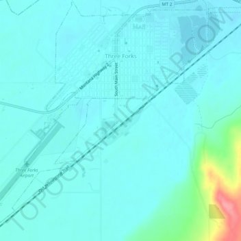
Name: Three Forks topographic map, elevation, terrain.
Location: Three Forks, Gallatin County, Montana, United States (45.86781 -111.58054 45.90006 -111.53467)
Average elevation: 1,249 m
Minimum elevation: 1,236 m
Maximum elevation: 1,327 m
Make a donation
Gear up for your next adventure:
As an Amazon Associate, this site earns from qualifying purchases at no extra cost to you.
Other topographic maps
Click on a map to view its topography, its elevation and its terrain.
Gallatin Gateway
United States > Montana > Gallatin County
Gallatin Gateway is a census-designated place (CDP) in Gallatin County, Montana, United States. As of the 2020 census, Gallatin Gateway had a population of 967. Elevation is 4,953 ft (1,510 m).
Average elevation: 1,519 m
Make a donation
Gear up for your next adventure:
As an Amazon Associate, this site earns from qualifying purchases at no extra cost to you.
Make a donation
Gear up for your next adventure:
As an Amazon Associate, this site earns from qualifying purchases at no extra cost to you.
Bozeman
United States > Montana > Gallatin County > Bozeman
Bozeman is located at an elevation of 4,820 feet (1,470 m). The Bridger Mountains are to the north-northeast, the Tobacco Root Mountains to the west-south-west, the Big Belt Mountains and Horseshoe Hills to the northwest, the Hyalite Peaks of the northern Gallatin Range to the south and the Spanish Peaks of…
Average elevation: 1,679 m