
Make a donation
Gear up for your next adventure:
As an Amazon Associate, this site earns from qualifying purchases at no extra cost to you.
Semmes topographic map
Click on the map to display elevation.
Make a donation
Gear up for your next adventure:
As an Amazon Associate, this site earns from qualifying purchases at no extra cost to you.
Semmes
Semmes is located at 30.778N, -88.259W. Elevation is 256 feet. The Semmes area is bounded to the North by the Citronelle area, bounded to the East by the cities of Saraland and Prichard, bounded to the South by the city of Mobile, and finally bounded to the West by Big Creek Lake.
Make a donation
Gear up for your next adventure:
As an Amazon Associate, this site earns from qualifying purchases at no extra cost to you.
About this map
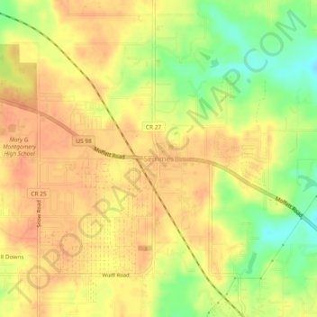
Name: Semmes topographic map, elevation, terrain.
Location: Semmes, Mobile County, Alabama, 36575, United States (30.75869 -88.27884 30.79869 -88.23884)
Average elevation: 68 m
Minimum elevation: 40 m
Maximum elevation: 82 m
Make a donation
Gear up for your next adventure:
As an Amazon Associate, this site earns from qualifying purchases at no extra cost to you.