Geolocate

Llanllowell topographic map

Click on the map to display elevation.

About this map

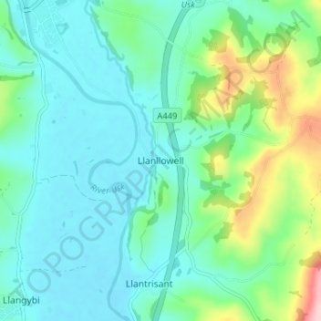
Name: Llanllowell topographic map, elevation, terrain.

Location: Llanllowell, Monmouthshire, Wales, NP15 1LJ, United Kingdom (51.66306 -2.90009 51.70306 -2.86009)

Average elevation: 52 m

Minimum elevation: 7 m

Maximum elevation: 212 m

Monmouthshire trails, hiking, mountain biking, running and outdoor activities

Gear up for your next adventure:

🧤Waterproof Overmitts - Extreme weather protection for hikers and mountaineers
👟Heavy Duty Boot Laces - Always carry a spare for your hiking footwear
👕Merino Base Layers - Natural temperature regulation for cold weather hiking and camping
🥾Women's Waterproof Hiking Boots - High-performance trekking boots designed for all-weather comfort
🧺Microfibre Travel Towels - Fast-drying and compact towels for wild swimming and camping

As an Amazon Associate, this site earns from qualifying purchases at no extra cost to you.