Geolocate

Kings County topographic map

Click on the map to display elevation.

About this map

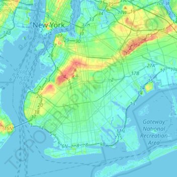
Name: Kings County topographic map, elevation, terrain.

Location: Kings County, New York, United States (40.55034 -74.05669 40.73943 -73.83295)

Average elevation: 9 m

Minimum elevation: -8 m

Maximum elevation: 62 m

Other topographic maps

Click on a map to view its topography, its elevation and its terrain.

Todt Hill

United States > New York > New York

Average elevation: 75 m

Snug Harbor Cultural Center and Botanical Garden

United States > New York > New York

Building C, also known as the Administration Building, was completed in 1833 and is Lafever's oldest surviving work. As of 2020, building C houses part of the Newhouse Center for Contemporary Art. The building consists of two stories, a raised basement, and an attic; it is rectangular in plan with a gable…

Average elevation: 20 m

Todt Hill

United States > New York > New York

Average elevation: 50 m

Saw Mill Creek

United States > New York > New York

Average elevation: 3 m

Spuyten Duyvil Hill

United States > New York > New York

Average elevation: 21 m

Vault Hill

United States > New York > New York

Average elevation: 41 m

Flushing Meadows-Corona Park

United States > New York > New York

Around 1907, contractor Michael Degnon, whose firm constructed the Williamsburg Bridge, the Cape Cod Canal, and the Steinway subway tunnel (used by today's 7 and <7>​ trains), purchased large tracts of marsh near Flushing Creek. At the time, the land was considered "all but worthless". Degnon envisioned…

Average elevation: 15 m

Fort Greene Park

United States > New York > New York

Average elevation: 17 m

Lenox Hill

United States > New York > New York

Average elevation: 20 m

Flushing Bay

United States > New York > New York

Average elevation: 4 m

Gravesend Bay

United States > New York > New York

Average elevation: 2 m

Hunter Island

United States > New York > New York

Average elevation: 42 m

Lookout Hill

United States > New York > New York

Average elevation: 32 m

Veterans Park

United States > New York > New York

Average elevation: 9 m

Kaiser Park

United States > New York > New York

Average elevation: 2 m

Twin Island

United States > New York > New York

Average elevation: 41 m

Emerson Hill

United States > New York > New York

Average elevation: 53 m

Sylvan Water

United States > New York > New York

Average elevation: 25 m

Lawrence Point

United States > New York > New York

Average elevation: 4 m

Willets Point

United States > New York > New York

Average elevation: 2 m

Gear up for your next adventure:

🧥Softshell Jackets - Breathable jackets for active outdoor use
Lightweight Solo Tents - Backpacking tents designed for wild camping in the UK highlands
🗺️Topographic Maps - Detailed maps showing elevation and terrain features
🌂Windproof Trekking Umbrellas - Surprising but effective rain protection on low-wind trails
🥤Hydration Bladders - Hands-free hydration systems for backpacks

As an Amazon Associate, this site earns from qualifying purchases at no extra cost to you.