
Thank you for supporting this site ❤️
Make a donation
Make a donation
Gear up for your next adventure:
As an Amazon Associate, this site earns from qualifying purchases at no extra cost to you.
Sparks topographic map
Click on the map to display elevation.
Thank you for supporting this site ❤️
Make a donation
Make a donation
Gear up for your next adventure:
As an Amazon Associate, this site earns from qualifying purchases at no extra cost to you.
About this map
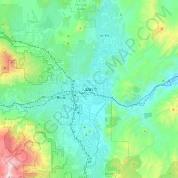
Name: Sparks topographic map, elevation, terrain.
Location: Sparks, Washoe County, Nevada, 89431-5025, United States (39.38047 -119.90872 39.70047 -119.58872)
Average elevation: 1,636 m
Minimum elevation: 1,300 m
Maximum elevation: 3,108 m
Thank you for supporting this site ❤️
Make a donation
Make a donation
Gear up for your next adventure:
As an Amazon Associate, this site earns from qualifying purchases at no extra cost to you.