
Wintersett topographic map
Interactive map
Click on the map to display elevation.
About this map
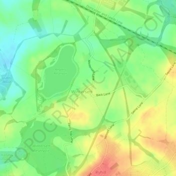
Name: Wintersett topographic map, elevation, terrain.
Average elevation: 66 m
Minimum elevation: 41 m
Maximum elevation: 96 m
Other topographic maps
Click on a map to view its topography, its elevation and its terrain.
Nostell
United Kingdom > England > West Yorkshire > Wakefield > Nostell
Nostell, Wakefield, West Yorkshire, England, WF4 1QR, United Kingdom
Average elevation: 60 m
Warmfield
United Kingdom > England > West Yorkshire > Wakefield > Warmfield
Warmfield, Wakefield, West Yorkshire, Yorkshire and the Humber, England, WF1 5TR, United Kingdom
Average elevation: 47 m