Geolocate

Cleveland topographic map

Click on the map to display elevation.

About this map

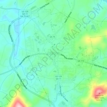
Name: Cleveland topographic map, elevation, terrain.

Location: Cleveland, White County, Georgia, 30528, United States (34.57994 -83.78088 34.61391 -83.73424)

Average elevation: 479 m

Minimum elevation: 423 m

Maximum elevation: 650 m

Other topographic maps

Click on a map to view its topography, its elevation and its terrain.

Nacoochee

United States > Georgia > White County

Average elevation: 449 m

Sautee

United States > Georgia > White County

Average elevation: 441 m

Yonah Mountain

United States > Georgia > White County

Average elevation: 619 m

Gear up for your next adventure:

Lightweight Tents - Compact tents for backpacking and trekking
🐕Hiking Dog Harnesses - Rugged harnesses for taking your companion on mountain trails
🔦Head Torches - Hands-free lighting for hiking and camping
🦟Anti-Midge & Tick Repellent - Vital for hiking in the Scottish Highlands during summer
🔦Outdoor Torches - Reliable torches for night navigation

As an Amazon Associate, this site earns from qualifying purchases at no extra cost to you.