Geolocate

Nacoochee topographic map

Click on the map to display elevation.

About this map

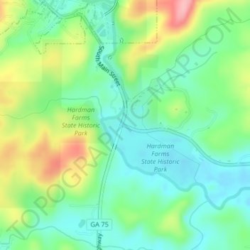
Name: Nacoochee topographic map, elevation, terrain.

Location: Nacoochee, White County, Georgia, 30545, United States (34.67510 -83.72046 34.69510 -83.70046)

Average elevation: 449 m

Minimum elevation: 404 m

Maximum elevation: 537 m

Other topographic maps

Click on a map to view its topography, its elevation and its terrain.

Cleveland

United States > Georgia > White County

Average elevation: 479 m

Unicoi State Park

United States > Georgia > White County > Helen

Average elevation: 540 m

Helen

United States > Georgia > White County

Average elevation: 488 m

Yonah

United States > Georgia > White County > Yonah

Average elevation: 491 m

Cleveland

United States > Georgia > White County

Average elevation: 479 m

Cleveland

United States > Georgia > White County

Average elevation: 479 m

Gear up for your next adventure:

🔥Emergency Fire Starters - Reliable ignition tools for survival situations in damp conditions
🛰️Outdoor GPS Navigation - Navigation devices for remote and off-grid areas
🥄Titanium Camping Sporks - The ultimate lightweight utensil for trail meals
🧣Neck Gaiters - Protects against wind and sun on exposed ridges and peaks
🥤Collapsible Water Bottles - Save space in your rucksack as you consume your water

As an Amazon Associate, this site earns from qualifying purchases at no extra cost to you.