Geolocate

Truckee topographic map

Click on the map to display elevation.

About this map

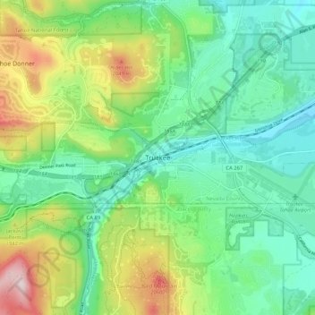
Name: Truckee topographic map, elevation, terrain.

Location: Truckee, Nevada County, California, 96161, United States (39.28796 -120.22325 39.36796 -120.14325)

Average elevation: 1,859 m

Minimum elevation: 1,734 m

Maximum elevation: 2,140 m

Other topographic maps

Click on a map to view its topography, its elevation and its terrain.

Donner Lake

United States > California > Nevada County > Truckee

Average elevation: 1,979 m

Donner Lake

United States > California > Nevada County > Truckee

Average elevation: 1,979 m

Gear up for your next adventure:

👖Convertible Hiking Trousers - Versatile zip-off pants for changing mountain weather conditions
📢Survival Whistles - Essential safety gear for signaling for help in mountain fog
🦯Walking Poles - Supportive poles for long-distance walking
🥤Hiking Water Bottles - Reusable bottles for hydration on the trail
🦟Anti-Midge & Tick Repellent - Vital for hiking in the Scottish Highlands during summer

As an Amazon Associate, this site earns from qualifying purchases at no extra cost to you.