
Thank you for supporting this site ❤️
Make a donation
Make a donation
Gear up for your next adventure:
As an Amazon Associate, this site earns from qualifying purchases at no extra cost to you.
Muchac topographic map
Click on the map to display elevation.
Thank you for supporting this site ❤️
Make a donation
Make a donation
Gear up for your next adventure:
As an Amazon Associate, this site earns from qualifying purchases at no extra cost to you.
About this map
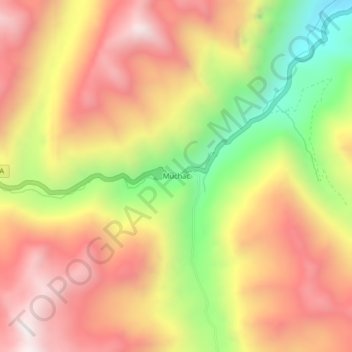
Name: Muchac topographic map, elevation, terrain.
Location: Muchac, Comas, Provincia de Concepción, Junín, Perú (-11.78976 -75.17217 -11.74976 -75.13217)
Average elevation: 4,229 m
Minimum elevation: 3,624 m
Maximum elevation: 4,691 m
Thank you for supporting this site ❤️
Make a donation
Make a donation
Gear up for your next adventure:
As an Amazon Associate, this site earns from qualifying purchases at no extra cost to you.