Geolocate

Oslob topographic map

Click on the map to display elevation.

About this map

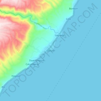
Name: Oslob topographic map, elevation, terrain.

Location: Oslob, Cebu, Central Visayas, Philippines (9.48123 123.39251 9.56123 123.47251)

Average elevation: 126 m

Minimum elevation: 0 m

Maximum elevation: 705 m

Gear up for your next adventure:

🧣Neck Gaiters - Protects against wind and sun on exposed ridges and peaks
🔦Keychain LED Torches - Emergency backup light for finding gear in your pack
🚲Cycling GPS Computers - Track elevation and topographic routes on two wheels
👟Women's Trail Running Shoes - Agile footwear for fell running and technical trails
🎒Hiking Daypacks - Compact backpacks ideal for short hikes and excursions

As an Amazon Associate, this site earns from qualifying purchases at no extra cost to you.