
Make a donation
Gear up for your next adventure:
As an Amazon Associate, this site earns from qualifying purchases at no extra cost to you.
Shiloh topographic map
Click on the map to display elevation.
Make a donation
Gear up for your next adventure:
As an Amazon Associate, this site earns from qualifying purchases at no extra cost to you.
Shiloh
Shiloh is located west of the center of DeKalb County at 34°27′56″N 85°52′38″W / 34.46556°N 85.87722°W / 34.46556; -85.87722 at an elevation of 1,263 feet (385 m). It is bordered to the northeast by the city of Rainsville and to the southwest by the town of Fyffe. Alabama State Route 75 passes through Shiloh, connecting Rainsville and Fyffe.
Make a donation
Gear up for your next adventure:
As an Amazon Associate, this site earns from qualifying purchases at no extra cost to you.
About this map
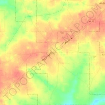
Name: Shiloh topographic map, elevation, terrain.
Location: Shiloh, DeKalb County, Alabama, United States (34.45012 -85.89501 34.48078 -85.85989)
Average elevation: 378 m
Minimum elevation: 352 m
Maximum elevation: 394 m
Make a donation
Gear up for your next adventure:
As an Amazon Associate, this site earns from qualifying purchases at no extra cost to you.