
Make a donation
Gear up for your next adventure:
As an Amazon Associate, this site earns from qualifying purchases at no extra cost to you.
Lakeside Park topographic map
Click on the map to display elevation.
Make a donation
Gear up for your next adventure:
As an Amazon Associate, this site earns from qualifying purchases at no extra cost to you.
About this map
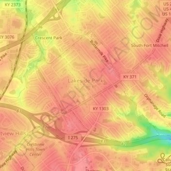
Name: Lakeside Park topographic map, elevation, terrain.
Location: Lakeside Park, Kenton County, Kentucky, 41017, United States (39.02600 -84.57911 39.04356 -84.55411)
Average elevation: 255 m
Minimum elevation: 199 m
Maximum elevation: 273 m
Make a donation
Gear up for your next adventure:
As an Amazon Associate, this site earns from qualifying purchases at no extra cost to you.
Other topographic maps
Click on a map to view its topography, its elevation and its terrain.
Make a donation
Gear up for your next adventure:
As an Amazon Associate, this site earns from qualifying purchases at no extra cost to you.
Sunny Acres
United States > Kentucky > Kenton County > Taylor Mill > Sunny Acres
Average elevation: 216 m