
Île Seguin topographic map
Interactive map
Click on the map to display elevation.
About this map
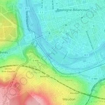
Name: Île Seguin topographic map, elevation, terrain.
Average elevation: 67 m
Minimum elevation: 23 m
Maximum elevation: 167 m
Other topographic maps
Click on a map to view its topography, its elevation and its terrain.
Jardin de la Mairie
France > Île-de-France > Hauts-de-Seine > Boulogne-Billancourt
Jardin de la Mairie, Centre Ville, Boulogne-Billancourt, Hauts-de-Seine, Île-de-France, France métropolitaine, 92100, France
Average elevation: 52 m
Jardin Albert Kahn
France > Île-de-France > Hauts-de-Seine > Boulogne-Billancourt
Jardin Albert Kahn, Parchamp - Albert Kahn, Boulogne-Billancourt, Hauts-de-Seine, Île-de-France, France métropolitaine, 92100, France
Average elevation: 56 m