
Lamu topographic map
Interactive map
Click on the map to display elevation.
About this map
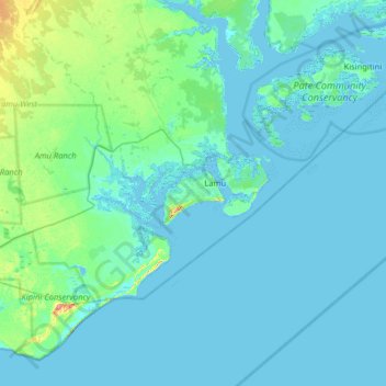
Name: Lamu topographic map, elevation, terrain.
Location: Lamu, Kenya (-2.60467 40.54403 -1.96467 41.18403)
Average elevation: 7 m
Minimum elevation: -1 m
Maximum elevation: 70 m
Other topographic maps
Click on a map to view its topography, its elevation and its terrain.
Shela
Kenya > Lamu > Lamu West > Shella ward
Shela, Shella ward, Lamu West, Lamu, Coastal Kenya, Kenya
Average elevation: 5 m
Jipe
Kenya > Lamu > Lamu West > Hindi ward
Jipe, Hindi ward, Lamu West, Lamu, Kenya
Average elevation: 10 m
Lamu
Kenya > Lamu > Lamu West > Mkomami ward
Lamu, Mkomami ward, Lamu West, Lamu, Coastal Kenya, Kenya
Average elevation: 4 m
Barigoni / Bargoni
Kenya > Lamu > Barigoni / Bargoni
Barigoni / Bargoni, Lamu, Coastal Kenya, Kenya
Average elevation: 17 m