
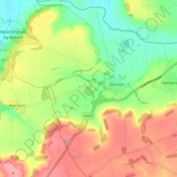
Denton CP topographic map
Interactive map
Click on the map to display elevation.
About this map
Name: Denton CP topographic map, elevation, terrain.
Average elevation: 105 m
Minimum elevation: 53 m
Maximum elevation: 162 m
Other topographic maps
Click on a map to view its topography, its elevation and its terrain.
Swayfield
United Kingdom > England > South Kesteven > Swayfield
Swayfield, South Kesteven, Lincolnshire, East Midlands, England, NG33 4LQ, United Kingdom
Average elevation: 82 m
Morton
United Kingdom > England > South Kesteven > Morton
Morton, South Kesteven, Lincolnshire, East Midlands, England, PE10 0PF, United Kingdom
Average elevation: 18 m
North Witham
United Kingdom > England > South Kesteven > North Witham
North Witham, South Kesteven, Lincolnshire, East Midlands, England, NG33 5LG, United Kingdom
Average elevation: 115 m
Kirkby Underwood
United Kingdom > England > South Kesteven > Kirkby Underwood
Kirkby Underwood, South Kesteven, Lincolnshire, East Midlands, England, PE10 0SF, United Kingdom
Average elevation: 51 m
Sedgebrook
United Kingdom > England > South Kesteven > Sedgebrook
Sedgebrook, South Kesteven, Lincolnshire, East Midlands, England, NG32 2ES, United Kingdom
Average elevation: 50 m
Burton le Coggles
United Kingdom > England > South Kesteven > Burton le Coggles
Burton le Coggles, South Kesteven, Lincolnshire, East Midlands, England, NG33 4JZ, United Kingdom
Average elevation: 87 m
Osgodby
United Kingdom > England > South Kesteven > Osgodby
Osgodby, South Kesteven, Lincolnshire, East Midlands, England, NG33 4JJ, United Kingdom
Average elevation: 68 m
Bourne CP
United Kingdom > England > South Kesteven
Bourne CP, South Kesteven, Lincolnshire, East Midlands, England, United Kingdom
Average elevation: 10 m
Grimsthorpe Castle
United Kingdom > England > South Kesteven
Grimsthorpe Castle, North Avenue, Edenham CP, South Kesteven, Lincolnshire, East Midlands, England, PE10 0LZ, United Kingdom
Average elevation: 54 m
Bourne Eau
United Kingdom > England > South Kesteven
Bourne Eau, South Kesteven, Lincolnshire, East Midlands, England, PE10 0DW, United Kingdom
Average elevation: 3 m
Londonthorpe and Harrowby Without CP
United Kingdom > England > South Kesteven
Londonthorpe and Harrowby Without CP, South Kesteven, Lincolnshire, East Midlands, England, United Kingdom
Average elevation: 100 m
Stamford CP
United Kingdom > England > South Kesteven
Stamford CP, South Kesteven, Lincolnshire, East Midlands, England, United Kingdom
Average elevation: 48 m
Caythorpe CP
United Kingdom > England > South Kesteven
Caythorpe CP, South Kesteven, Lincolnshire, East Midlands, England, United Kingdom
Average elevation: 59 m
West Deeping CP
United Kingdom > England > South Kesteven
West Deeping CP, South Kesteven, Lincolnshire, East Midlands, England, United Kingdom
Average elevation: 11 m
Market Deeping CP
United Kingdom > England > South Kesteven
Market Deeping CP, South Kesteven, Lincolnshire, East Midlands, England, United Kingdom
Average elevation: 5 m