Geolocate

Agnes topographic map

Click on the map to display elevation.

About this map

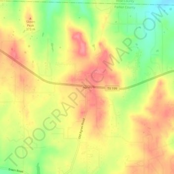
Name: Agnes topographic map, elevation, terrain.

Location: Agnes, Parker County, Texas, 76482, United States (32.95929 -97.80864 32.99929 -97.76864)

Average elevation: 351 m

Minimum elevation: 303 m

Maximum elevation: 385 m

Other topographic maps

Click on a map to view its topography, its elevation and its terrain.

Weatherford

United States > Texas > Parker County

Average elevation: 326 m

Reno

United States > Texas > Parker County

Average elevation: 233 m

Aledo

United States > Texas > Parker County

Average elevation: 271 m

Springtown

United States > Texas > Parker County

Average elevation: 273 m

Millsap

United States > Texas > Parker County

Average elevation: 257 m

Snake Forest

United States > Texas > Parker County

Average elevation: 312 m

Aledo

United States > Texas > Parker County

Average elevation: 271 m

Weatherford

United States > Texas > Parker County

Average elevation: 326 m

Gear up for your next adventure:

🌄Compact Monoculars - Lightweight optics for hiking
🧥Waterproof Hiking Jackets - Rain protection for walking in all weather conditions
🥫Expedition Meals - Lightweight, high-calorie nutrition for long-distance hikers
🍳Camping Stoves - Compact stoves for outdoor cooking
🔋Rechargeable Batteries - Eco-friendly power for headlamps and older GPS units

As an Amazon Associate, this site earns from qualifying purchases at no extra cost to you.