
Make a donation
Gear up for your next adventure:
As an Amazon Associate, this site earns from qualifying purchases at no extra cost to you.
Waterford topographic map
Click on the map to display elevation.
Make a donation
Gear up for your next adventure:
As an Amazon Associate, this site earns from qualifying purchases at no extra cost to you.
Waterford
The city was founded around the Tuolumne River. City population signs report Waterford's elevation is 51 feet (16 m) above sea level.
Make a donation
Gear up for your next adventure:
As an Amazon Associate, this site earns from qualifying purchases at no extra cost to you.
About this map
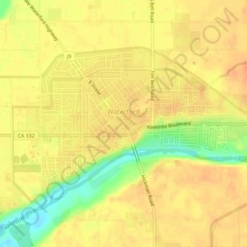
Name: Waterford topographic map, elevation, terrain.
Location: Waterford, Stanislaus County, California, United States (37.62990 -120.77866 37.64962 -120.73859)
Average elevation: 49 m
Minimum elevation: 20 m
Maximum elevation: 61 m
Make a donation
Gear up for your next adventure:
As an Amazon Associate, this site earns from qualifying purchases at no extra cost to you.
Other topographic maps
Click on a map to view its topography, its elevation and its terrain.