Geolocate

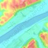
Florence topographic map

Click on the map to display elevation.

About this map

Name: Florence topographic map, elevation, terrain.

Location: Florence, Switzerland County, Indiana, 47020, United States (38.76423 -84.94439 38.80423 -84.90439)

Average elevation: 162 m

Minimum elevation: 135 m

Maximum elevation: 246 m

Other topographic maps

Click on a map to view its topography, its elevation and its terrain.
Vevay

United States > Indiana > Switzerland County

Average elevation: 164 m

Patriot

United States > Indiana > Switzerland County

Average elevation: 169 m

Vevay

United States > Indiana > Switzerland County

Average elevation: 164 m

Gear up for your next adventure:

⛺Lightweight Solo Tents - Backpacking tents designed for wild camping in the UK highlands
🧣Neck Gaiters - Protects against wind and sun on exposed ridges and peaks
🖼️Topographic Map Art - Decorative 3D-effect posters of famous UK peaks and regions
🧥Breathable Waterproof Jackets - Essential rain protection for the unpredictable British climate
🎒Backpack Rain Covers - Universal waterproof covers to protect your gear from downpours

As an Amazon Associate, this site earns from qualifying purchases at no extra cost to you.