
Kali Ngara topographic map
Interactive map
Click on the map to display elevation.
About this map
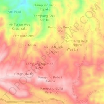
Name: Kali Ngara topographic map, elevation, terrain.
Location: Kali Ngara, Sumba Barat Daya, East Nusa Tenggara, Indonesia (-9.51441 119.24432 -9.47441 119.28432)
Average elevation: 457 m
Minimum elevation: 249 m
Maximum elevation: 564 m
Other topographic maps
Click on a map to view its topography, its elevation and its terrain.
Bondokodi
Indonesia > East Nusa Tenggara > Sumba Barat Daya > Bondokodi
Bondokodi, Sumba Barat Daya, East Nusa Tenggara, Indonesia
Average elevation: 36 m