Geolocate

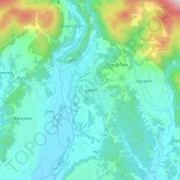
Jvari topographic map

Click on the map to display elevation.

Jvari

Jvari (Georgian: ჯვარი) is a town in the northwestern Georgian province of Samegrelo-Zemo Svaneti. The town is situated at an altitude of 280 metres near the Magana River where it flows into the Enguri River; The town is divided in two with "Jvari" lying on the Zugdidi-Mestia highway, and Jvarzeni (Upper Jvari) up the hill.

Wikipedia (CC-BY-SA 3.0)

About this map

Name: Jvari topographic map, elevation, terrain.

Location: Jvari, Tsalenjikha Municipality, Samegrelo-Upper Svaneti, 5200, Georgia (42.67757 42.00964 42.75757 42.08964)

Average elevation: 450 m

Minimum elevation: 222 m

Maximum elevation: 1,410 m

Other topographic maps

Click on a map to view its topography, its elevation and its terrain.

Gear up for your next adventure:

🗺️Topographic Maps - Detailed maps showing elevation and terrain features
👖Convertible Hiking Trousers - Versatile zip-off pants for changing mountain weather conditions
🔋Lithium AA Batteries - Long-lasting power that performs well in cold mountain weather
🔋Rechargeable Batteries - Eco-friendly power for headlamps and older GPS units
💧Hydration Reservoirs - Convenient water bladders for hands-free drinking on the move

As an Amazon Associate, this site earns from qualifying purchases at no extra cost to you.