
Tralaroche topographic map
Interactive map
Click on the map to display elevation.
About this map
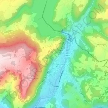
Name: Tralaroche topographic map, elevation, terrain.
Average elevation: 580 m
Minimum elevation: 418 m
Maximum elevation: 812 m
Other topographic maps
Click on a map to view its topography, its elevation and its terrain.
Les Orgues
France > Nouvelle-Aquitaine > Corrèze > Bort-les-Orgues
Les Orgues, Bort-les-Orgues, Ussel, Corrèze, Nouvelle-Aquitaine, France métropolitaine, 19110, France
Average elevation: 603 m
Saint-Thomas
France > Nouvelle-Aquitaine > Corrèze > Bort-les-Orgues
Saint-Thomas, Bort-les-Orgues, Ussel, Corrèze, Nouvelle-Aquitaine, France métropolitaine, 19110, France
Average elevation: 521 m