
Gemeinde Jochberg topographic map
Interactive map
Click on the map to display elevation.
About this map
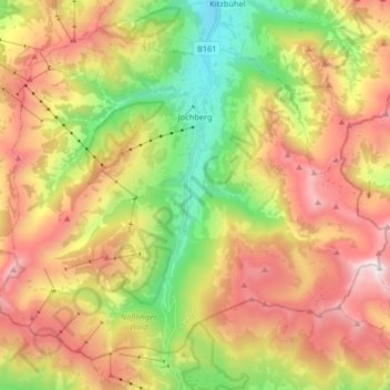
Name: Gemeinde Jochberg topographic map, elevation, terrain.
Location: Gemeinde Jochberg, Bezirk Kitzbühel, Tirol, 6373, Österreich (47.31131 12.33526 47.40479 12.49860)
Average elevation: 1,524 m
Minimum elevation: 798 m
Maximum elevation: 2,333 m
Die komplette Liste der Statistik Austria ist in: Topographische Siedlungskennzeichnung nach STAT
Other topographic maps
Click on a map to view its topography, its elevation and its terrain.
Going
Österreich > Tirol > Bezirk Kitzbühel > Going am Wilden Kaiser
Going, Going am Wilden Kaiser, Bezirk Kitzbühel, Tirol, 6353, Österreich
Average elevation: 892 m