Geolocate

Puducherry District topographic map

Interactive map

Click on the map to display elevation.

About this map

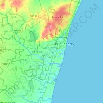
Name: Puducherry District topographic map, elevation, terrain.

Location: Puducherry District, Puducherry, India (11.77523 79.59942 12.05098 79.87460)

Average elevation: 12 m

Minimum elevation: -4 m

Maximum elevation: 63 m

Other topographic maps

Click on a map to view its topography, its elevation and its terrain.

Villianur

India > Puducherry > Villianur Taluk

Average elevation: 13 m

Veerampattinam

India > Puducherry > Puducherry Taluk

Average elevation: 3 m

Karaikal

India > Puducherry > Karaikal Taluk

Average elevation: 3 m

Yanam

India > Puducherry > Yanam Taluk

Average elevation: 5 m

Nedungadu

India > Puducherry > Nedungadu

Average elevation: 5 m

Oulgaret

India > Puducherry > Ozhukarai Taluk

Average elevation: 18 m