Geolocate

Massy topographic map

Click on the map to display elevation.

About this map

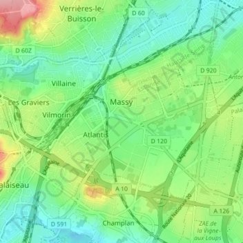
Name: Massy topographic map, elevation, terrain.

Location: Massy, Palaiseau, Essonne, Ile-de-France, Metropolitan France, 91300, France (48.71196 2.23501 48.74081 2.30421)

Average elevation: 84 m

Minimum elevation: 44 m

Maximum elevation: 166 m

Other topographic maps

Click on a map to view its topography, its elevation and its terrain.

La Roche

France > Ile-de-France > Essonne

Average elevation: 91 m

Paris Basin

France > Ile-de-France > Essonne > Bièvres

The landscape is one of very broad valleys (flood plains), modest watershed hills and well-drained plateaux of comparatively little altitude. In the south-east and east the plain of Champagne and the Seuil de Bourgogne (Threshold of Burgundy) differential erosion of the strata has left low scarps with the dip…

Average elevation: 126 m

Gear up for your next adventure:

🧣Neck Gaiters - Versatile protection against wind and cold
🌄Outdoor Binoculars - Compact binoculars for landscape observation
Lightweight Solo Tents - Backpacking tents designed for wild camping in the UK highlands
🗺️Ordnance Survey Maps - Essential paper maps for hiking across the UK national parks
🗺️Ordnance Survey Maps - Official UK maps for walking and outdoor activities

As an Amazon Associate, this site earns from qualifying purchases at no extra cost to you.