
Jay Peak topographic map
Interactive map
Click on the map to display elevation.
About this map
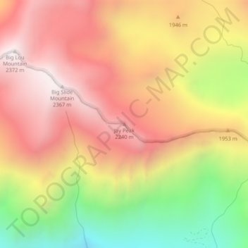
Name: Jay Peak topographic map, elevation, terrain.
Location: Jay Peak, Chelan County, Washington, États-Unis d'Amérique (47.63132 -120.82958 47.63142 -120.82948)
Average elevation: 1,829 m
Minimum elevation: 1,104 m
Maximum elevation: 2,357 m
Other topographic maps
Click on a map to view its topography, its elevation and its terrain.
Manson
États-Unis d'Amérique > Washington > Chelan County
Manson, Chelan County, Washington, 98831, États-Unis d'Amérique
Average elevation: 362 m
Stehekin
États-Unis d'Amérique > Washington > Chelan County
Stehekin, Chelan County, Washington, 98852, États-Unis d'Amérique
Average elevation: 683 m