
Bolesworth Castle topographic map
Interactive map
Click on the map to display elevation.
About this map
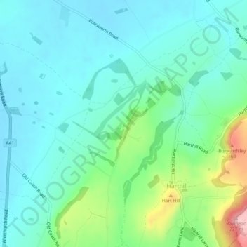
Name: Bolesworth Castle topographic map, elevation, terrain.
Average elevation: 80 m
Minimum elevation: 39 m
Maximum elevation: 221 m
Other topographic maps
Click on a map to view its topography, its elevation and its terrain.
Bolesworth Fish Pond
United Kingdom > England > Cheshire West and Chester > Harthill > Broxton
Bolesworth Fish Pond, Broxton, Harthill, Cheshire West and Chester, England, United Kingdom
Average elevation: 75 m