
Make a donation
Gear up for your next adventure:
As an Amazon Associate, this site earns from qualifying purchases at no extra cost to you.
Robertsganj topographic map
Click on the map to display elevation.
Make a donation
Gear up for your next adventure:
As an Amazon Associate, this site earns from qualifying purchases at no extra cost to you.
Robertsganj
Robertsganj is located at 24°42′N 83°04′E / 24.7°N 83.07°E / 24.7; 83.07. It has an average elevation of 330 metres (1080 feet) from sea level. Robertsganj is located in the south-eastern ranges of the Vindhyachal mountain.
Make a donation
Gear up for your next adventure:
As an Amazon Associate, this site earns from qualifying purchases at no extra cost to you.
About this map
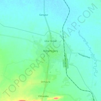
Name: Robertsganj topographic map, elevation, terrain.
Location: Robertsganj, Sonbhadra, Uttar Pradesh, 231216, India (24.64981 83.02530 24.72981 83.10530)
Average elevation: 313 m
Minimum elevation: 301 m
Maximum elevation: 360 m
Make a donation
Gear up for your next adventure:
As an Amazon Associate, this site earns from qualifying purchases at no extra cost to you.