
Choczewo topographic map
Interactive map
Click on the map to display elevation.
About this map
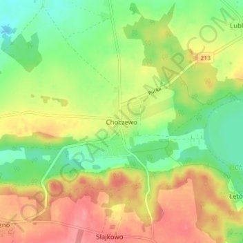
Name: Choczewo topographic map, elevation, terrain.
Average elevation: 67 m
Minimum elevation: 32 m
Maximum elevation: 104 m
Other topographic maps
Click on a map to view its topography, its elevation and its terrain.
Jezioro Żarnowieckie
Poland > Pomeranian Voivodeship > Wejherowo County > Czymanowo
Jezioro Żarnowieckie, Czymanowo, gmina Gniewino, Wejherowo County, Pomeranian Voivodeship, 84-250, Poland
Average elevation: 37 m
Łęczyce
Poland > Pomeranian Voivodeship > Wejherowo County
Łęczyce, gmina Łęczyce, Wejherowo County, Pomeranian Voivodeship, Poland
Average elevation: 52 m
Rumia
Poland > Pomeranian Voivodeship > Wejherowo County > Rumia
Rumia, Wejherowo County, Pomeranian Voivodeship, 84-230, Poland
Average elevation: 69 m
Szemud
Poland > Pomeranian Voivodeship > Wejherowo County > Szemud
Szemud, gmina Szemud, Wejherowo County, Pomeranian Voivodeship, Poland
Average elevation: 186 m
Reda
Poland > Pomeranian Voivodeship > Wejherowo County > Reda
Reda, Wejherowo County, Pomeranian Voivodeship, 84-240, Poland
Average elevation: 57 m
Mierzyno
Poland > Pomeranian Voivodeship > Wejherowo County
Mierzyno, gmina Gniewino, Wejherowo County, Pomeranian Voivodeship, 84-250, Poland
Average elevation: 70 m
Wejherowo
Poland > Pomeranian Voivodeship > Wejherowo County > Wejherowo
Wejherowo, Wejherowo County, Pomeranian Voivodeship, Poland
Average elevation: 71 m